Fast company logo
|
advertisement

Using annotated satellite imagery, historical redlining maps, and archival photos, Segregation by Design highlights 180 American cities decimated by racist planning.

Segregation By Design: How one architect is visualizing the legacy of America’s racist urbanism

[Source Photo: simonkr/Getty Images]

BY Gabe Boyd3 minute read

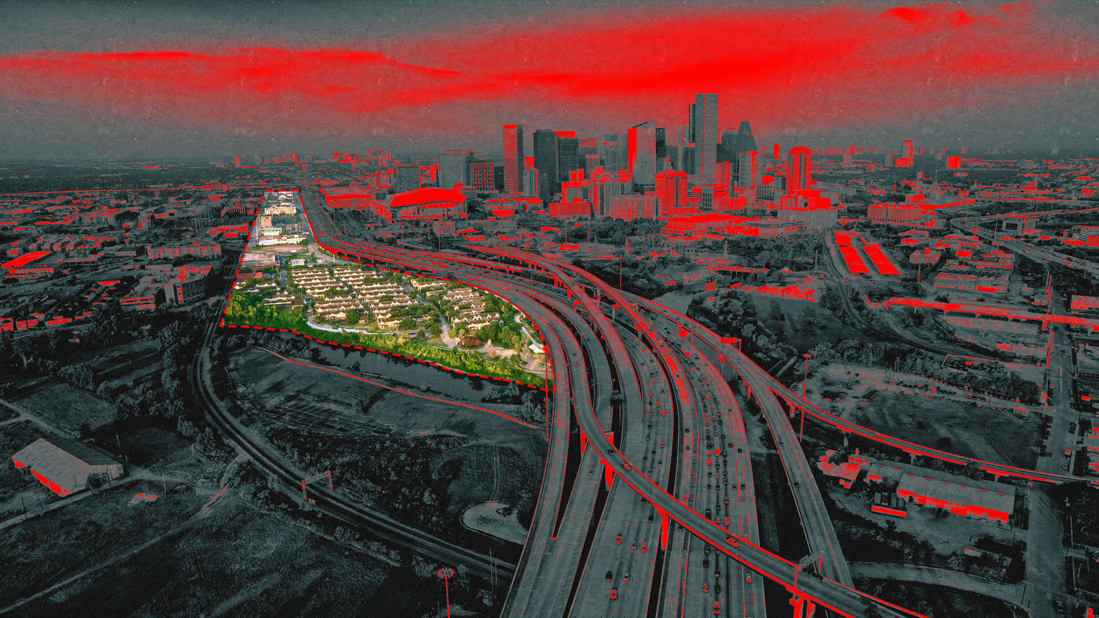
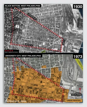
Walking around the north side of Philadelphia’s University City neighborhood, it’s difficult to imagine what stood before the sprawling University of Pennsylvania medical campus, replete with scores of half-empty parking lots and franchise restaurants. But for Segregation By Design, a new initiative that seeks to unearth the legacy of racist planning in American cities, the visual history is clear. What stood before University City was Black Bottom, a thriving Black working-class community whose proximity to Philadelphia’s urban core made it a prime target for the 1950s slum clearance, freeway construction, and redevelopment projects that decimated hundreds of low-income neighborhoods across the country.  

Segregation by Design, which takes the form of a blog-style website, various social media pages, and a forthcoming book helps long-time residents and the urban-curious alike visualize the legacy of racist urbanism. The project shows neighborhoods impacted by redlining (a term for race-based exclusionary tactics in real estate), federally funded “urban renewal” projects, and environmental racism. It joins a larger conversation about the ways in which supposedly neutral public planning has disproportionately affected low-income communities of color. 

[Image: courtesy Segregation By Design]
“I read The Color of Law and was frustrated that there weren’t more pictures,” jokes Adam Paul Susaneck, the New York-based architect who leads the project. The Color of Law by Richard Rothstein is a much-cited book exploring the history of racial segregation as an outcome of explicit government policies. “I was trying to figure out why American cities are the way they are,” Susaneck says. What started as a curious inquiry into Berkeley, California’s public transit system evolved into an ongoing visual exploration of the public infrastructure that perpetuates segregation. “A lot of people just haven’t considered the built environment in a critical fashion,” Susaneck says. “It’s hard to imagine what things were like before.”

Using annotated satellite imagery, historical redlining maps, and archival photos, Susaneck hopes to profile 180 American cities that received federal funding from either the 1949 Federal Housing Act or the 1956 Federal Highway Act, two pieces of legislation which greenlit devastating and discriminatory infrastructure projects around the country. So far, with funds from a Patreon account and Columbia University’s Graduate School of Architecture and Public Planning incubator prize, Susaneck has completed 11 cities. 

[Image: courtesy Segregation By Design]
Roxbury, Boston, is a textbook example of how freeway construction decimated the center of Black culture in Boston and continues to burden a majority-Black neighborhood. In the 1960s, the creation of the I-95 freeway and slum clearance efforts carried out by the Boston Redevelopment Agency razed about half of the neighborhood’s buildings and displaced over 5,000 families. While activists were ultimately successful in stopping freeway construction, the damage was already done: Public spaces were eviscerated, access to train transit was wiped away, and forced displacement left the neighborhood in shambles. Among the buildings destroyed: 36 Dabney Place, a six-story Victorian-style residence in the center of Roxbury. Today, what stands in its place is an awkwardly shaped half-empty parking lot.  

Susaneck shows what Roxbury looked liked through photos like the one above, maps of the neighborhood, and narrative explanations of how affected communities have fought against injustice. Susaneck is hopeful that his work will add a missing visual narrative to a growing urban planning movement that decries car-centered development and seeks to restore and rejuvenate public spaces.

[Image: courtesy Segregation By Design]
His project is already gaining traction. In Houston, The Stop TX DOT I-45 activist group began showcasing Susaneck’s high-resolution maps at local planning board meetings. Susaneck’s maps clearly depicted what would be destroyed if Houston’s I-45 freeway were to be widened: 486 public housing units, 433 apartments, 340 businesses, 158 houses, five churches, and two schools. “All you need to do is make a map, and then people are like, ‘Wait, what?'” Susaneck says. While the impact of the group’s advocacy work is pending, Susaneck remains optimistic that his visuals can aid grassroots advocacy around progressive urbanism.  

Segregation By Design joins the conversation at a time of unprecedented spending on American infrastructure. The Infrastructure Investment and Jobs Act of 2021 unlocks over $1 trillion to remake cities with the promise of a better future. While more money is not the only answer to the mechanisms of oppressive public planning, it’s a promising start. For Susaneck and his passion project, understanding urban planning’s racist past is the key to constructing more equitable cities in the future—filled with accessible public transit, pedestrian-friendly roads, and ample public space for all. 

Recognize your brand’s excellence by applying to this year’s Brands That Matter Awards before the final deadline, June 7.

Sign up for Brands That Matter notifications here.

CoDesign Newsletter logo
The latest innovations in design brought to you every weekday.
This site is protected by reCAPTCHA and the Google Privacy Policy and Terms of Service apply.
Privacy Policy

ABOUT THE AUTHOR

Gabriel Cary Boyd was an editorial intern for Fast Company, covering topics ranging from tech and government to Gen Z to breaking news. You can connect with Gabriel on LinkedIn More


Explore Topics