If you’ve been on social media the past few days, you’ve no doubt come across videos of parts of Texas covered in flames and choking smoke. The dystopian sights are due to parts of the state being inundated with wildfires, particularly in the Texas panhandle, which borders New Mexico and Oklahoma.
At one point the fires have been so severe that a Texas nuclear weapons facility needed to be briefly shut down. Across the panhandle, unseasonably warm temperatures, dry grass, and strong winds have been fueling the fires.
For those interested in tracking the latest location and statuses of the various wildfires, there are a couple of online mapping resources that provide snapshots of where the fires are.
FIRMS
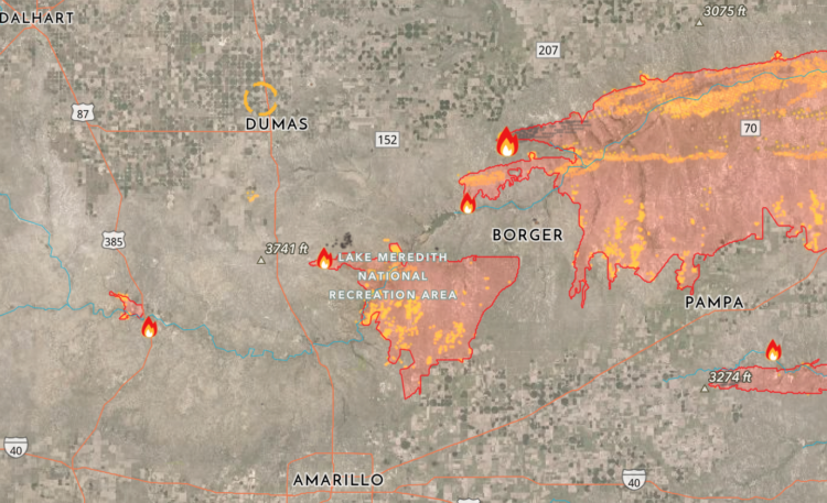
The first map is from the Fire Information for Resource Management Systems (FIRMS), which uses data from NASA and the Forest Service of the United States Department of Agriculture. What is particularly informative about this map is that you can see where fires are that have not been declared contained, controlled, or put out yet. You can toggle the map to show these active fires based upon their size.
AirNow
The second map is the AirNow Fire and Smoke Map, which is a collaboration between the U.S. Forest Service (USFS)-led Interagency Wildland Fire Air Quality Response Program and the U.S. Environmental Protection Agency (EPA). This map reveals fire and smoke plume locations and also shows the current particle pollution air-quality information for the user’s location.
Incident Information – Texas A&M Forest Service
Another good resource for those who want to track the status of the fires is the Incident Information – Texas A&M Forest Service account on X (formerly Twitter). The account has been posting updates on where the fires are and how contained any given fire is.
The Texas A&M Forest Service also offers its own map, which tracks current fires and past fires that have been contained or extinguished.
WildFire Aware
The interactive WildFire Aware tool from Esri lets you select any fire in the country and view various data points, such as air quality, the fire’s perimeters, and the demographics of the impacted area.
The current Texas wildfires are believed to be the second largest in the state’s history. As of the time of this writing, there is only one known fatality so far, an 83-year-old woman, reports the Associated Press. However, that number could rise as the fires continue and authorities commence searches for victims.
Recognize your brand’s excellence by applying to this year’s Brands That Matter Awards before the early-rate deadline, May 3.