Residents from Hawaii to Texas to the Caribbean are bracing for impact this weekend as not one but three named storms take aim at land.
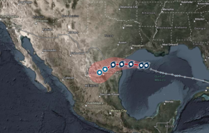
Hurricane Douglas, the first Eastern Pacific hurricane of the season, is expected to hit the Hawaiian islands on Sunday, the National Weather Service said. Meanwhile, Tropical Storm Hanna is heading toward Texas and could bring up to 12 inches of rain Sunday in the southern part of that state. But that’s not all—there’s also Tropical Storm Gonzalo farther east in the Caribbean, which is approaching the southern Windward Islands this morning, according to the National Hurricane Center. That storm could end up being the first hurricane of the Atlantic hurricane season, which has already been historically busy with activity.
If you’re looking to stay on top of the so-called triple threat of storms this weekend, I’ve rounded up a few useful maps and tools below that let you track hurricanes, cyclones, and tropical storms in real time.
Recognize your brand’s excellence by applying to this year’s Brands That Matter Awards before the early-rate deadline, May 3.