
Almost 200,000 people in North Carolina were without power on Friday morning as Hurricane Dorian lashed the eastern part of the state. Electrical crews, including thousands who came in from other states to assist as the storm approached, are spread out throughout North Carolina and working to restore power to affected customers, ABC11 in Raleigh-Durham reports.
According to the latest update from the National Weather Service, residents across the North Carolina coast—in addition to people in portions of southeast Virginia and the southern Chesapeake Bay—can expect life-threatening storm surges and dangerous winds as Dorian continues along its path.
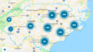
If you’re looking to track the power outages across North Carolina, a number of interactive maps lets you do that in real time. Currently, these maps show outages across large swaths of the state’s eastern counties. Here’s a partial list:
Recognize your brand’s excellence by applying to this year’s Brands That Matter Awards before the early-rate deadline, May 3.