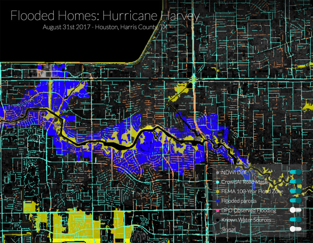
NDWI (Normalized Difference Water Index) – The NDWI identifies water content in the area and is the most appropriate index for mapping water. [Photo: Planet]
CrowdAI Road Mask – CrowdAI uses algorithms and satellite imagery to detect roads that may have be damaged or flooded, allowing emergency responders to better navigate through the city after a disaster. Orange roads are flooded (detectable before flooding, undetectable during flooding) and the blue roads are not flooded (detectable during flooding). [Photo: Planet]
FEMA 100 Year Flood Zone – This layer represents the Federal Emergency Management Agency’s (FEMA) predicted flood zones in the city of Houston. [Photo: Planet]
Flooded Parcels – Flooding from hurricane Harvey (shown in blue) far exceeded FEMA‘s Special Flood Hazard Area (SFHA). Flood insurance is mandatory within SFHA bounds. Planet’s data can provide a more accurate risk model for future flooding. [Photo: Planet]
Six years ago, a group of scientists and engineers, among them three former NASA employees, gathered in a garage in Cupertino, California, with a goal: to found a company whose mission was to capture an image of Earth’s entire landmass every day. To do so, Planet Labs, as they called themselves (they’ve since rebranded to become Planet), had to use satellites small enough and cost-effective enough to launch en masse in a “fleet” that could traverse Earth, snapping images and collecting data.
They settled on CubeSat satellites–devices no bigger than a shoebox, and built with consumer smartphone technology for imaging and data collection (the first of this type of CubeSat were built by NASA’s Ames Research Center and inspired by first-generation Google Android phones. The small remote-controlled box, equipped with sensors, floated two miles above the Earth via balloons). As Planet evolved, they began designing and building their own mini satellites, which they call “doves,” and updated their technology simply by switching out the smartphone used for the latest model.
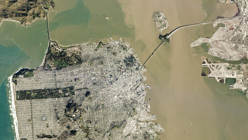
San Francisco [Photo: Planet]By choosing not to be precious with their technology, and instead integrating whatever the market has to offer, Planet has been able to keep its costs low–and as such, launch the greatest number of satellites into orbit at once. Since its founding six years ago, Planet has grown from a team of seven people to 500, and has launched over 300 satellites on various rocket-launch missions. Its “Mission 1” of imaging Earth’s entire landmass every day, wrote co-founder Will Marshallon Planet’s blog, is officially complete. We’re used to the idea ofsatellite imagery and mapping, but the format we’re most familiar with–Google Maps–is only updated every five or so years. Planet’s volume and speed of imagery are unprecedented.
Currently, Planet is operating around 200 satellites that travel a pole-to-pole path through the atmosphere, capturing around 1.4 million images per day as they go and feeding it back to 30 ground stations the company set up across the world. That work, Marshall added, will continue. Planet has become a lifeline of vital data for a number of companies that rely on consistent, up-to-date imagery to inform their work.
Flooded Parcels – Flooding from hurricane Harvey (shown in blue) far exceeded FEMA’s Special Flood Hazard Area (SFHA). Flood insurance is mandatory within SFHA bounds. Planet’s data can provide a more accurate risk model for future flooding. [Photo: Planet]Planet’s two biggest clients, currently, are governments and precision agriculture companies. Companies likeFarmers Edge, a farm and agriculture management company, can arrange a contract (often to the tune of tens of millions of dollars) with Planet to access their stream of satellite imagery. By analyzing the images, they can detect the health of crops (for instance, applying an infrared filter to the images shows concentrations of chlorophyll, which signals unhealthy vegetation), and how it changes over time. Similarly, governments and research agencies can use Planet’s images to monitor land loss due to climate change, track deforestation, and observe development patterns from above. In the aftermath of the hurricanes that struck Florida, Texas, andPuerto Ricothis fall, Planet’s data proved invaluable to humanitarian and governmental missions needing to swiftly identify the hardest-hit areas.
What’s next for Planet, Marshall wrote, is “building a platform that can harness and make sense of this massive amount of information, to enable users to answer their questions.” The company, he added is working on developing object-recognition capabilities that would, for instance, enable users to count how many homes are in a specific area, or build out custom information feeds, like, Marshall writes, a tally of the number of ships in the biggest global ports at any given time.
“In short,” Marshall wrote, “Planet will index physical change on Earth the same way Google indexed the internet.” Now that the company has completed its goal of photographing the planet in real time, it’s moving on to help its users put that data to the best possible use.
Recognize your brand’s excellence by applying to this year’s Brands That Matter Awards before the final deadline, June 7.
Sign up for Brands That Matter notifications here.
A refreshed look at leadership from the desk of CEO and chief content officer Stephanie Mehta
Eillie Anzilotti is an assistant editor for Fast Company's Ideas section, covering sustainability, social good, and alternative economies. Previously, she wrote for CityLab.More