Fast company logo
|
advertisement

Google says that it wants to help people make informed decisions about where to go and what they can safely do there.

Google Maps adds COVID-19 case numbers and trends for 220 countries

[Source image: Kolonko/iStock]

BY Mark Sullivan

You can use Google Maps to find out how much traffic lies between you and where you’re going. And starting this week, you can use the same app to find out how big a problem the coronavirus may be in that area—or anywhere else.

The company says in a blog post today that it’s added a COVID-19 layer to its Android and iOS Maps apps. The new feature shows COVID-19 case numbers and trends for many cities, as well as counties, provinces, and 220 countries around the world. You just open the app and tap on the “layers” button on the top right-hand corner of your screen, and then click on “COVID-19 info.”

                  The COVID-19 layer in Google’s Maps app. [Image: Google]
The map layer shows a seven-day average of new COVID-19 cases per 100,000 people and an arrow that shows whether the number is trending up or down. The color of the type indicates the density of the new cases in an area, Google says.

advertisement

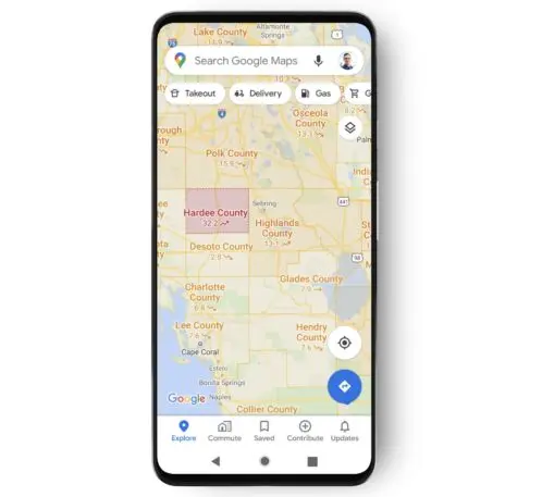
The COVID-19 data comes from sources including Johns Hopkins University, The New York Times, and Wikipedia.

Recognize your brand's excellence by applying to this year's Brands That Matters Awards before the early-rate deadline, May 3.

PluggedIn Newsletter logo
Sign up for our weekly tech digest.
This site is protected by reCAPTCHA and the Google Privacy Policy and Terms of Service apply.
Privacy Policy

ABOUT THE AUTHOR

Mark Sullivan is a senior writer at Fast Company, covering emerging tech, AI, and tech policy. Before coming to Fast Company in January 2016, Sullivan wrote for VentureBeat, Light Reading, CNET, Wired, and PCWorld More


Explore Topics