From high-up satellite images to close-up Street View panoramas, Google Earth is a great way to see the world—at least as Google wants to present it. But now you can use Google Earth to build your own world tour using a new feature called Creation Tools. In essence, you can pick any place or collection of places on the globe and add text, media, and illustrations to create your own story about the places. It’s a DIY version of the pro-created Voyager presentations that Google Earth launched two years ago.
To test it out, I decided to use Creation Tools as an excuse to subject friends to more of my vacation photos and videos—in this case from a visit to Jordan last January. (Of course, that’s just one possible use of Creation Tools. Google also touts it as an educational resource, for instance.)
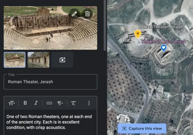
Starting from the main Google Earth page, I clicked the new Projects icon on the left-side toolbar and named mine “Jordan Trip.” Then I began searching for locations, like the capital, Amman, and the ancient cities of Jerash and Petra. Google dropped a map pin in the middle of each site, but I could move it around to select a specific location, down to a particular temple and theater in Jerash (although Google Earth doesn’t have such high resolution for every single place).
I could even customize the color and style of the pin. For a video I shot on the road to the Dead Sea, there wasn’t a specific place to search for, so I just dragged a pin to the spot that looked about right. At each pin, I could add text to describe my experience and upload up to eight photos and/or videos—allowing me to make a mini slide show for any location.
You don’t need to shoot your own media—or ever visit the location yourself—to use Creation Tools. By default, each major pin location has descriptive text and photos supplied by Google Earth. I took advantage of them for the Red Sea port of Aqaba, which I’d visited but didn’t take many photos of. If I wanted, I could have also searched for images and videos that other people had shot and added them to my project.
You can also add other multimedia that it is difficult to shoot on a smartphone. For instance, you can do 360-degree, 3D flybys of the many locations in Google Earth. Creation Tools now let you record a particular flyby route—like once around the Roman Coliseum at a particular height and angle—that plays back when you share a project with friends. Not all sites are in such high resolution as the Coliseum, though. Petra is just a bunch of brownish blobs in Google Earth’s 360-degree view. But the site includes Street View images that provide great photos around the ancient city.
There are a few downsides to Creation Tools, however. The biggest is that they, and Google Earth itself, run best in the company’s Chrome browser. (There is a beta version of Earth for a few other browsers, including Firefox, Edge, and Opera—but not Safari.) You can view everything on the Google Earth Android and iOS apps, but you can’t create your own projects on phones or tablets.
Beyond that, there are a few small usability issues, including a fair amount of back and forth in creating a project. For instance, I had to click the upload window and drag and drop an image for each picture I wanted to add, rather than drag a pile over all at once. And I couldn’t simply drag in videos. I had to first upload them to YouTube, then copy and paste the link into the Creation Tools interface.
Related: Google’s new VR tours let you experience imperiled cultural sites around the world
It can also take a long time to create a project. I spent about two hours building a five-location project about my Jordan trip (though it may have taken longer because I kept adding and tweaking elements until it was perfect). That means it certainly won’t replace Instagram as the easiest way to show a lot of people where I’ve been and what I’ve seen.
But Google Earth projects offer a richer experience in many ways. Instead of pointing to an imaginary map and trying to explain to friends where every photo was taken, I could let them explore a 3D world at their own pace and see and learn a lot more of each place than just what I’d captured and learned in a few days.
Recognize your brand’s excellence by applying to this year’s Brands That Matter Awards before the early-rate deadline, May 3.
