


The reverberations of climate change and planetary warming are felt in all sorts of ways, from weather patterns that feel decidedly unseasonal to rapidly melting polar ice caps. As the oceans’ temperatures rise, so too do their tides; it’s predicted that over 570 low-lying coastal cities will face 1.5 feet in sea level rise by 2050.
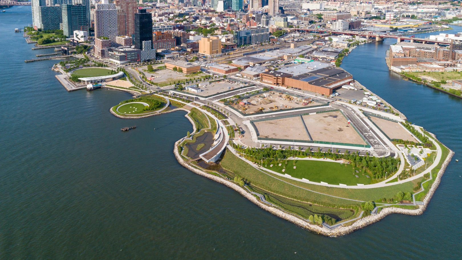
New York, which is bordered by the East River on one edge, is one of these cities left vulnerable to changing tides and hurricanes. City officials and planners are racing to prepare the city to withstand flooding, with several large-scale resilience projects underway today. But smaller, site-specific projects could help New York adapt, too: Take the new public park project, Hunter’s Point South Waterfront Park, which is designed to protect its Long Island City home from rising flood waters through repurposing abandoned industrial land.
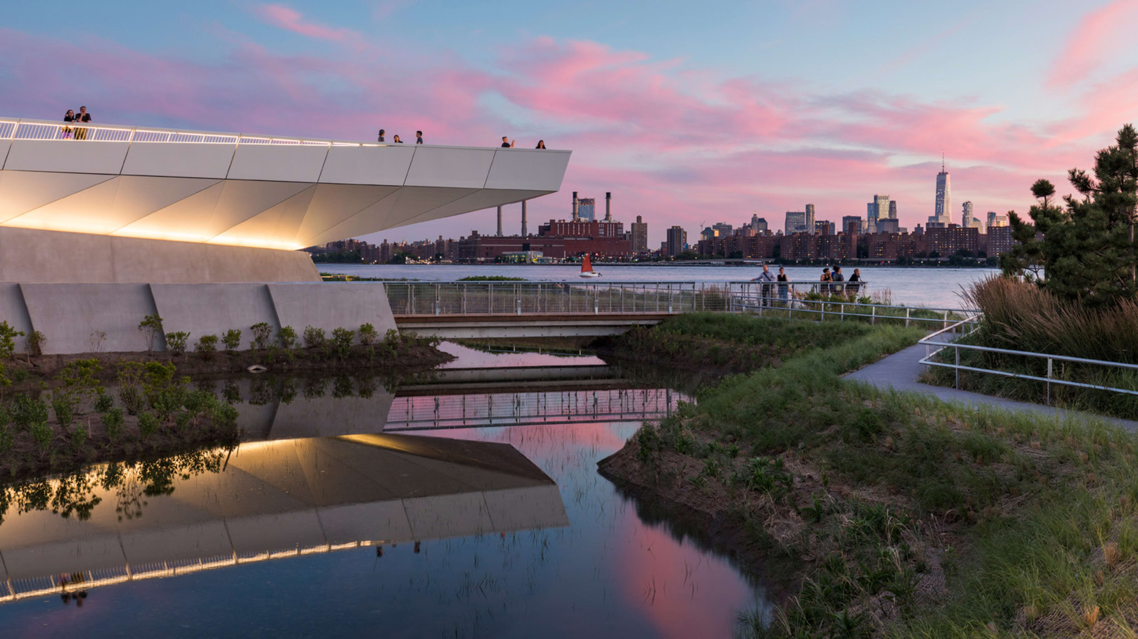
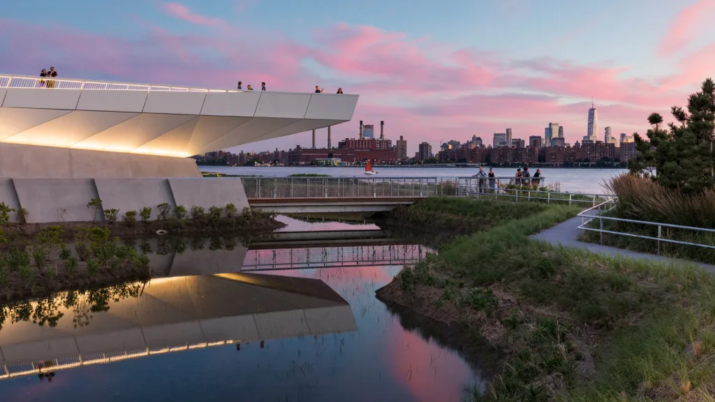
The 30-acre park was designed by SWA/Balsley and Weiss/Manfredi, and boasts a playground, urban beach, exercise terrace, cafe-bar, and more. The mercurial East River—which has left New York residents vulnerable to sudden natural disasters like Hurricane Sandy—runs parallel to the park, and along it, the team of architects, landscape architects, and engineers developed a causeway engineered with sustainability in mind. This protective walkway guards against potential tidal currents that could harm the neighboring upland community and new waterside habitat.
Water management in coastal cities has become an increasingly important part of infrastructure to consider when designing safe—and equitable—urban areas.
“In the case of the park, what we really needed to do was think about how this river was actually embracing the water as opposed to pushing it out,” says Marion Weiss. “And so it really is thinking comprehensively about the storm water runoffs to the rising sea level question every city is facing.”
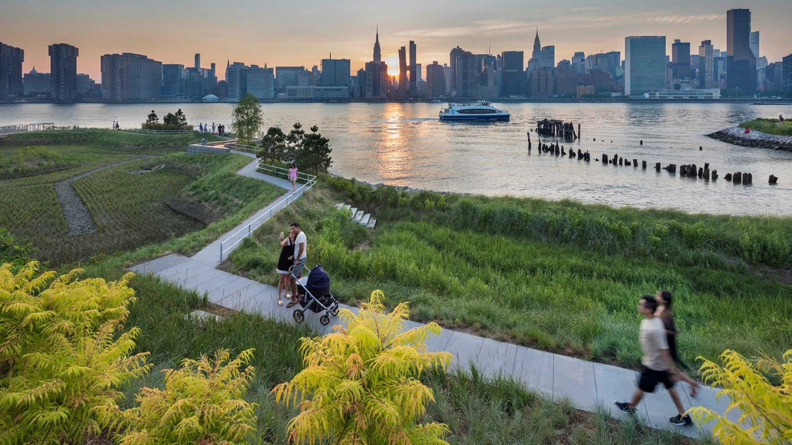
The park’s marshland serves as a natural form of storm absorption against the wills of the East River’s rugged current; the designers further bolstered this shoreline with the help of a supporting walkway, which doubles as a scenic outlook.
“The East River is technically not a river but a tidal strait,” says Weiss. “And as a result, the direction of the tides change and the water levels rise twice a day, tied to the lunar calendar. The temporal relationship with water is expressed with the wetlands on the edge of the park.”
The public park is littered with various water management tools hiding in plain sight. Concrete benches divert storm flood water, the cafe’s roof catches rain for reuse, and the grassy soccer field is conveniently lined with drains.
Weiss’s collaborator, Thomas Balsley, first designed the master plan for the entire Hunter’s Point South shoreline in 1993, which he says “was a prelude to what we as a team were thinking about when we were starting to imagine the landscape architecture for [the park].”
Balsley and his collaborators took a holistic approach to resiliency—a complex problem—without sacrificing the social and cultural components that are necessary to a public park’s success. Now, the park exists jointly as an innovative piece of infrastructure and also a shared space for the larger community looking for a place to relax, participate in outdoor sports, or simply look out on the riparian vista. For the affordable housing developments just adjacent to the site (some of which are still in progress), this is a particularly satisfying green space.
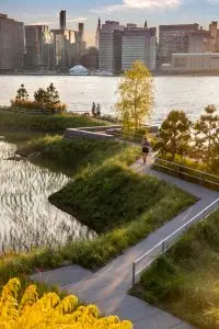
This project has the highest WEDG (Waterfront Edge Design Guidelines) certification of any park in New York, and achieved that score thanks to the social benefits of the park like picnic terraces and “break-out” lounge areas, as well as its environmental and ecological attributes, like native plantings, rugged materials, the tidal marsh, and porous paving.
Two hundred years ago, Hunter’s Point South Waterfront Park was a contaminated rail site surrounded by wetlands and marshes. The space formerly housed the Long Island Railway’s terminus, but was left to deteriorate into a forgotten landfill after the city excavated tunnels and built infrastructure elsewhere.
“There was an original heritage to this site,” says Balsley. In order to maintain the site’s history and also update it for a modern community (and environmentally different world), the team reimagined it as usable multipurpose space, while still preserving the natural beauty that has always existed. “[We have] this dialogue between a tidal marsh and the river and the skyline and [thought] how extraordinary that would be when you’re down by the water.”
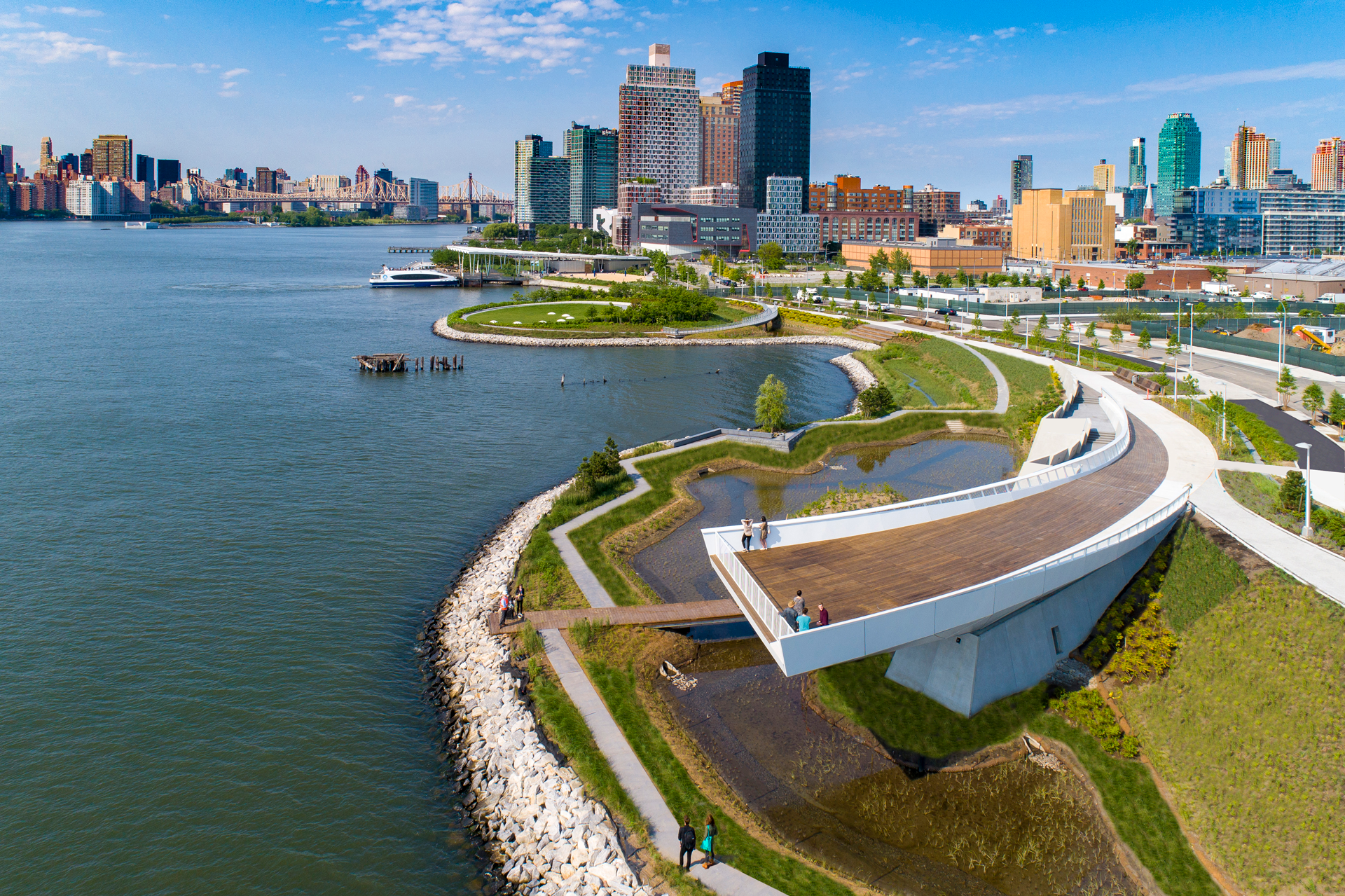
“What was very interesting was that the irregular land was creating [a varied] topography,” says Weiss. As part of the project to revive and enhance that topography, the designers pulled back an existing peninsula to create an island, which can be accessed via a bridge. The decision was made, in part, to protect the community from the whims of the water. She adds: “We were so excited that the need to create wetland habitats gave us the opportunity to create New York City’s newest island.”
This island-meets-tidal habitat marsh is anchored by Nobuho Nagasawa’s public art installation Luminescence, which illustrates the seven phases of the moon through glittery spheres.
The park was fully funded by the city—and it represents a rare and visionary commitment to environmentally conscious, waterfront resilience.
“Most developments occur with the buildings coming first and the public space comes next to accompany it,” says Weiss. “I think this was a magical confluence of a visionary moment in the Bloomberg administration . . . to recognize a public park that has equal interest in good design and ecological and infrastructural resilience.”
Recognize your brand’s excellence by applying to this year’s Brands That Matter Awards before the early-rate deadline, May 3.
